
Kashmir Great Lakes Trek
Trek Grade
Moderate-Difficult
Highest Altitude
13,750 ft.
Base Camp
Sonmarg
Trek Duration
8- Days
Overview
The Kashmir Great Lakes Trek is a long, demanding Himalayan trek meant for people who enjoy effort as much as scenery. If you are looking for a relaxed walk, this is not it. If you want to earn your views, it fits perfectly.
What makes this trek special is that you cross seven alpine lakes and three high passes on one continuous route. While other classic treks in Uttarakhand or Himachal Pradesh are often closed due to heavy rains, the Kashmir Great Lakes trek is in its prime during the monsoon.
The trek usually takes 7 to 8 days and covers close to 72 kilometres. You start from Sonamarg and finish at Naranag. The highest point is Gadsar Pass, which sits at around 13,750 feet. Most trekkers place it in the moderate to difficult category, and that rating is fair.
So who should do this trek? You should already be comfortable walking long hours. Most days involve 9 to 12 kilometres on foot, often for five to seven hours. Some climbs feel slow and never-ending, especially at altitude. This is why first-time trekkers usually struggle here. Fitness matters more than motivation on this trail.
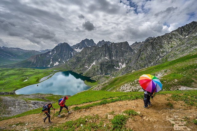
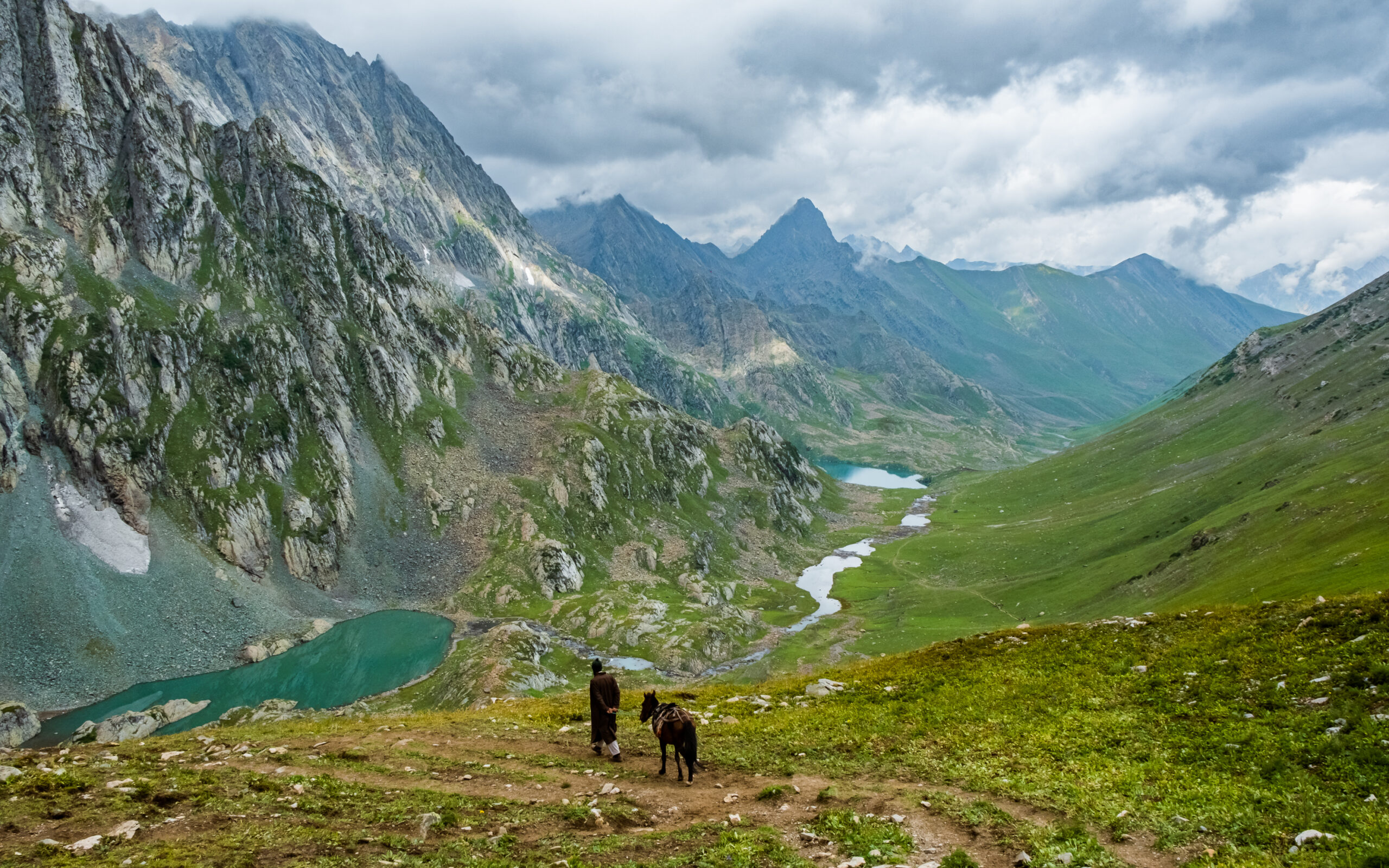
What keeps people going is the landscape. You don’t just see lakes from a distance. You walk beside them. You camp near them. Vishansar and Kishansar appear early and set the tone. Gadsar feels raw and isolated. Satsar stretches wide and quiet. Gangabal and Nundkol come at the end, backed by Mount Harmukh. Each lake feels different, not just in colour, but in mood.
There is also a cultural layer many people do not expect. Locals associate Vishansar with Lord Vishnu. Gangabal is considered sacred and linked with the Ganges (often called Harmukh Ganga). You feel that respect in how people talk about these places.
The best time to do the Kashmir Great Lakes Trek is July to September. Snow melts, meadows open up, and the lakes fill with colour. Days can be warm while walking, but nights get cold quickly.
This trek rewards preparation. If you train well and come with realistic expectations, it stays with you long after it ends.
Available Dates
July 2026
| Date | Status |
|---|---|
| 4 July 2026 | Open |
| 5 July 2026 | Open |
| 11 July 2026 | Open |
| 12 July 2026 | Open |
| 18 July 2026 | Open |
| 19 July 2026 | Open |
| 25 July 2026 | Open |
| 26 July 2026 | Open |
August 2026
| Date | Status |
|---|---|
| 1 Aug 2026 | Open |
| 2 Aug 2026 | Open |
| 8 Aug 2026 | Open |
| 9 Aug 2026 | Open |
| 15 Aug 2026 | Open |
| 16 Aug 2026 | Open |
| 22 Aug 2026 | Open |
| 23 Aug 2026 | Open |
| 29 Aug 2026 | Open |
| 30 Aug 2026 | Open |
September 2026
| Date | Status |
|---|---|
| 5 Sep 2026 | Open |
| 6 Sep 2026 | Open |
| 12 Sep 2026 | Open |
| 13 Sep 2026 | Open |
| 19 Sep 2026 | Open |
| 20 Sep 2026 | Open |
| 26 Sep 2026 | Open |
| 27 Sep 2026 | Open |
Kashmir Great Lakes Trek Highlights
- Beautiful Lakes: The trek takes you to stunning, high-altitude lakes like Vishansar, Krishansar, and Gadsar.
- Scenic Views: Enjoy breathtaking views of snow-capped mountains, lush green meadows, and deep valleys.
- Wildlife: Spot rare animals like Himalayan brown bears, marmots, and many types of birds.
- Adventure: The trek is thrilling with challenging passes like Gadsar Pass and others.
- Camping: Sleep under the stars at beautiful campsites near the lakes and meadows.
- Cultural Experience: Meet local shepherds and learn about life in the mountains.
Kashmir Great Lakes Trek Package and Cost
| Item | Cost |
|---|---|
| Trek Cost | 15,500 ₹/ Person |
| Transportation | 1500 INR |
| Offloading/ Porter Service | 300 ₹ Per Bag / Per Day |
| Insurance | 350₹ / Person |
This Kashmir Great Lakes Trek Package includes all costs for the trek. It covers camping gear, transport, meals, trained staff, medical help, and other essentials. TravElsket offers the best price with top service.
How to Book Your Trek
Booking your trek is easy! Just follow these simple steps:
- Send a Message: You can reach us on WhatsApp or fill out our inquiry form on the website. We will reply to you quickly.
- Inquiry Form: You can also fill out the inquiry form on our website, and we will contact you.
- Confirm Your Trek: Once we get your message, our team will contact you right away to confirm your trek. We will also help you with choosing add-ons (like backpack offloading, personalized help, or even pitching your own tent).
- Balance Payment: After your trek is confirmed, 30% advance payment is required to confirm your trek. You can pay with credit card, UPI, or bank transfer.
The remaining 70% amount must be paid at least 7 days before the trek start date. - Add-ons: You can add extra services like backpack offloading (₹2,400 per bag) or personalized help to make your trek special.
Cancellation and Refund Policy
We know plans can change, so we try to make things easy for you:
- Before Confirmation: If you cancel before we confirm your trek, you will get all your money back.
- After Confirmation: If you need to cancel later, you can move your trek to a new date. Just let us know within before 3 days.
- Cancellation 15+ days before arrival: 90% Refund.
- 8-14 days before arrival: 75% Refund
- 4-7 days before arrival: 50% refund
- 0-3 days before arrival: No Refund
Discounts and Special Offers
We offer discounts to make your trek even better:
- Early Bird Discount: Book at least 3 months ahead and save 5% on your trek.
- Group Discount: Book for a group of 4 or more and get 5% off your total trek cost.
Extra Info
- Buffer Day: It’s a good idea to plan a buffer day after the trek in case of delays.
- Arrive Early: Reach Srinagar at least one day before the trek start date to avoid flight delays, trail delays, or other disruptions.
- Transportation: We include transportation from Srinagar in the trek price. If you need extra transport, let us know.
- Gear Rental: We have trekking gear available for rent. Just let us know if you need it.
Kashmir Great Lakes Trek - Complete Information
Kashmir Great Lakes Trek Itinerary
Day 1: Arrival in Srinagar and Drive to Sonamarg (Shitkadi Base Camp)
- Reporting Point: Dal Lake area, Srinagar
- Reporting Time: 10:00 AM
- Trek Distance: No trekking
- Drive Distance: 85–90 km (3–4 hours)
- Altitude Gain: 5,200 ft (1,585 m) – 7,800 ft (2,377 m)
- Difficulty: Easy (travel day)
- Water Sources: Available at base camp
- Mobile Network: Limited to none after Sonamarg
The trek begins with a scheduled pickup from Srinagar and a drive to Sonamarg. This day involves travel only and no trekking. The goal is to reach the Shitkadi base camp comfortably and allow time for rest before the trek starts.
The journey starts late in the morning from Srinagar. You travel toward Sonamarg via Ganderbal. For most of the drive, the road runs along the Sindh River. City traffic fades fast, and the surroundings become open and quiet.
As the altitude increases, the air feels cooler. Meadows appear closer to Sonamarg. On clear days, peaks like Kolahoi, Machoi, and Amarnath can be seen from the road. The Machoi Glacier is also visible near Sonamarg.
Shitkadi is the official base camp for the trek. It is located slightly ahead of Sonamarg, close to the river. After arrival, you check into your camps and rest.
The afternoon is kept light for acclimatization. In the evening, the trek briefing takes place. This covers the route, daily distances, safety rules, and weather conditions. Dinner is served early. Trekking begins the next morning.
Important Notes
- Carry original government ID and two photocopies for the army check post
- Last reliable ATMs and shops are in Srinagar. Sonamarg ATMs are often unreliable.
- Avoid physical effort on the first day
- Keep warm clothes ready for the evening
- Mobile network may not work at the campsite
Day 2: Sonamarg (Shitkadi) to Nichnai via Shekdur
- Trek Distance: 11 km (7–8 hours)
- Altitude Gain: 7,800 ft (2,377 m) – 11,500 ft (3,505 m)
- Highest Point: Nichnai Campsite – 11,500 ft (3,505 m)
- Difficulty: Moderate
- Trail Type: Forest, meadows, rocky river valley
- Water Sources: Streams at Shekdur and Nichnai valley
- Mobile Network: Weak/None
The first 3 hours involve a steady uphill climb from Shitkadi. This is followed by a gentle descent through birch forest after Shekdur. The final 2 hours are a slow ascent along the Nichnai stream.
Leaving Sonamarg and the road behind
This is the first day where the trek begins to demand steady effort. Walking hours are long, and the climb rarely pauses. Many trekkers realise their true pace on this day. It also introduces landscapes that feel distinctly Kashmiri and unlike most Himalayan trails.
The trek starts from the Shitkadi area, around 3 km from Sonamarg town, along the Srinagar road. A small dhaba here sells packaged water and snacks. This is the last reliable place to buy anything before the trek fully enters wilderness.
Soon after, the trail leaves the road and follows a jeep track beside the Sindh River. Cold air rises from the water in the early morning, making the first stretch feel brisk.
Meadows above Sonamarg
Within the first half hour, the trail climbs into open meadows overlooking the Sonamarg valley. The ascent here is gradual and helps the body warm up. Many trekkers stop here without planning to, mostly to look back as the town slowly disappears.
Morning light is soft in this section, and this is usually the first natural photo stop of the day.
Maple forest and steady climb
The route then enters dense forests of Pine, Maple, and Bhoj (Silver Birch). This section continues for about two to two and a half hours with a consistent uphill gradient. Maple forests like these are uncommon on Indian treks, and the forest floor often feels damp underfoot.
The forest is quiet, and groups tend to spread out as everyone settles into a personal walking rhythm.
An army check post appears early in this forest section. All trekkers must show a valid ID here. Keep your Aadhaar Card or Passport, along with two photocopies, easily accessible. Depending on group size, this stop can take time and often breaks walking momentum. The sudden presence of the army is a reminder of how close this wilderness lies to inhabited valleys.
After the check post, brief views of the Sonamarg valley and the Thajiwas Glacier begin to open up behind you. These glimpses usually arrive just as fatigue sets in, and many trekkers pause here for photos on clear days.
Shekdur meadow and food stop
Shekdur meadow is reached after roughly four hours of trekking. This is a wide green clearing surrounded by Silver Birch trees. Small dhabas here sell tea, omelettes, and instant noodles. Finding hot food in a birch meadow is something quite unique to Kashmir.
Most groups stop here for rest or lunch. Water is available from nearby streams. Some trekkers also camp at Shekdur, though many continue onward since the day is still manageable.
Descent through birch forest
After Shekdur, the trail descends gently for about 45 minutes through dense birch forest. Sunlight filtering through the trees makes this section scenic. After rain, the path becomes slippery, and the smell of wet earth is strong.
This section, combined with the rocky terrain ahead, is where shoes with good grip and ankle support make a noticeable difference.
Nichnai river valley
The forest ends as the trail enters the Nichnai river valley. The path now follows the Nichnai stream upstream. This stretch involves rocky sections and slow progress, especially when mules are present. The constant sound of fast-flowing water stays with you through this part of the walk.
After about an hour, the valley opens into broad green meadows surrounded by high mountains. Snow-covered peaks become visible ahead, and most trekkers sense that the campsite is close. Late afternoon light here often turns this into another popular photo stop.
Nichnai campsite
The Nichnai campsite is located beside the stream on flat grassy ground. Clear water sources are easily accessible. Nights here are colder and windier than many expect for the first campsite. The steady wind and sound of running water become more noticeable after sunset, making warm layers essential.
Why this day stands out
Day 2 is physically demanding because of the long hours and continuous ascent. At the same time, it showcases nearly every landscape type on the trek, from river valleys and forests to open meadows and high mountain basins. This combination of effort, scenery, food stops, and sudden reminders of civilization gives the Kashmir Great Lakes trek much of its distinct character.
Day 3: Nichnai to Vishansar Lake via Nichnai Pass
- Trek Distance: 12–13 km (7–8 hours)
- Altitude Gain: 11,500 ft (3,505 m) – 12,000 ft (3,658 m)
- Highest Point: Nichnai Pass – 13,200 ft (4,023 m)
- Difficulty: Moderate to Difficult
- Trail Type: Meadows, rocky ascent, grassy descent
- Water Sources: Limited before pass; streams after pass
- Mobile Network: Last reliable signal at Nichnai Pass
If you are trekking from Nichnai to Vishansar Lake, expect a long and tiring day with fast altitude gain, even though the trail looks easy at first.
This day tests patience more than strength. Most of us feel fine in the morning, then slow down sharply after the pass. Knowing where effort increases helps us pace better.
We should start early. Not because the trail is risky, but because fatigue builds quietly on this stretch.
From Nichnai Camp to the Start of the Climb
The walk begins gently from Nichnai campsite at around 11,500 ft. The valley feels wide and open, and the ground stays soft underfoot. A stream runs beside the trail for the first part.
Within thirty minutes, we cross this stream and move to its left side. The slope still feels mild here, which often creates a false sense of ease. Many trekkers talk freely at this point and walk too fast.
That early speed usually shows its cost near the pass.
Ahead, two snow-covered peaks come into view. Nichnai Pass sits just to their right. Keeping this marker in mind helps, especially when clouds roll in.
The Ascent to Nichnai Pass (13,200 ft)
The climb starts slowly and stays steady. There are no sharp turns, just a long pull upward. Breathing becomes heavier, even when the legs still feel fine.
This is where many of us wonder why the climb feels harder than expected.
The reason is simple. Altitude gain comes quickly, and the body is still adjusting. Short steps work better than long ones here. Slow movement saves energy.
One detail often missed is this. The ridge seen from below is not the pass. The trail bends inward twice before the actual pass opens up. Celebrating too early can drain morale when more climbing appears.
At the top, views open toward Sonamarg and the route behind us. This is also the last reliable mobile network point on the trek. After this, phones usually stay silent until Gangabal.
We should not stay too long. Wind builds fast here, even on clear days.
The Descent That Tests Knees
The descent from Nichnai Pass begins on loose, rocky ground. It is steep enough to strain knees, especially without trekking poles.
If the trail is damp or icy early in the season, this section needs full attention. Rushing here is a common mistake. Controlled steps protect strength for later.
After about an hour, rocks thin out and grass takes over. The change feels sudden. One moment demands focus, the next feels relaxed.
A river flows down from the pass and guides us into the valley.
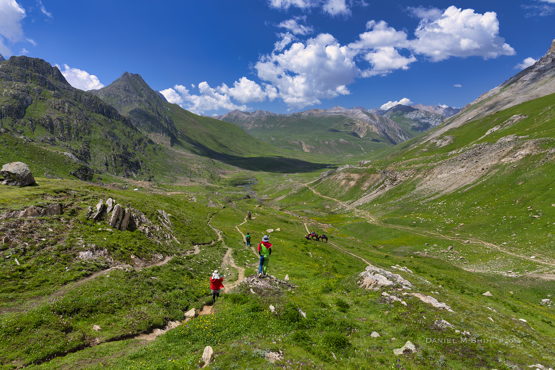
The Long Walk Through Vishansar Valley
This stretch looks easy but feels long. The valley opens wide, with snow-covered slopes on both sides. The trail stays mostly flat, which helps tired legs.
Two main streams cut across the meadow. Staying close to the left one keeps the route simpler. At least one stream crossing is expected, depending on the season.
In July, water often reaches knee height by afternoon. Backpacks should be unbuckled before crossing. Losing balance here usually comes from underestimating the current.
Mental fatigue often hits in this section. Many of us stop too long, thinking the campsite is near. It is not. Short, regular breaks work better.
Reaching Vishansar Campsite
Near the end of the valley, a stream flows from left to right. This stream comes directly from Vishansar Lake, which sits slightly higher and remains out of sight.
Tents are pitched here. The ground is flat and open, with enough space for large groups.
Vishansar Lake lies about half a kilometer away and roughly one hundred and seventy feet higher. The walk takes ten to fifteen minutes. We should go only if daylight and energy allow.
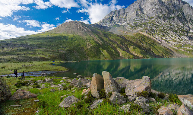
The lake rests below four surrounding mountains. On calm evenings, Kishansar peak reflects clearly on the surface. Early morning light shows the best colors.
Evening at Vishansar
Shepherds often bring sheep here during summer. Their presence feels natural, as if the valley has followed this rhythm for generations.
Fishing is allowed with permission from the Srinagar Fisheries Department. Winds increase after sunset, and temperatures drop quickly. Tents should be secured well before dark.
Day 3 is demanding, but it marks a turning point. Once we reach Vishansar, we know our bodies can handle the altitude. Rest matters here. The next day asks for discipline.
Day 4: Acclimatization + Rest Day (Conditions Apply)
Day 4 helps your body adjust to the higher altitude. This step is important for your safety and comfort during the trek. You will take a short walk to Kishansar Lake, which is only 0.5 km from Vishansar Lake. The path starts on the right side of Vishansar Lake and takes about 45 minutes.
Kishansar Lake is at the base of Kishansar Peak and offers stunning views. A large meadow on the right side of the lake is a great spot to take photos and relax.
The plan for acclimatization depends on the weather. If the weather is good, the trek might move forward without a rest day. In that case, the acclimatization break will happen later at Gangabal campsite.
Use this day to explore, relax, and prepare for the journey ahead!
Day 5: Vishansar to Gadsar Lake via Gadsar Pass
- Trek Distance: 14–16 km (7–8 hours, excluding army delays)
- Altitude Gain: 12,000 ft (3,658 m) – 12,000 ft (3,658 m)
- Highest Point: Gadsar Pass – 13,750 ft (4,191 m)
- Difficulty: Difficult (hardest day)
- Trail Type: Steep rocky ascent, scree descent, meadows
- Water Sources: Carry 2L from Vishansar; refill after Yamsar Lake
- Mobile Network: None
- Special Note: Army checkpoint – expect 1–3 hour delays
The journey feels different once you leave Vishansar behind. It is the toughest and most decisive day of the Kashmir Great Lakes trek, combining maximum altitude, long distance, and real on-trail judgment. This day looks manageable on paper. On the trail, it demands discipline.
The Climb to Gadsar Pass (1.5–2 Hours)
We leave Vishansar early because late starts make this day harder than it needs to be. The climb begins almost immediately, and there is no gentle warm-up. Your breathing deepens fast, and pace matters more than strength.
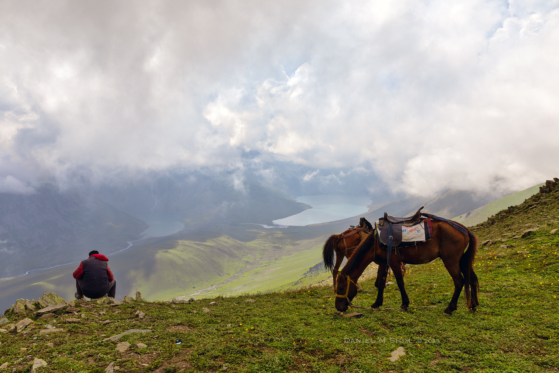
The trail cuts across the slope instead of climbing straight up. This saves energy, but it tempts people to walk faster than they should. We have seen strong trekkers drain themselves here simply by ignoring rhythm. About an hour in, most people stop naturally. Not from exhaustion, but because the view behind demands it. Vishansar and Kishansar sit far below, calm and unreal. We always pause here, hydrate, and let the heart rate settle.
At the Pass: Wind, Cold, Quick Exit
The final push to the pass slows everyone down. Air thins. Steps shorten. Mild AMS signs can appear here. Headache, slight nausea, or irritability are common. None of these mean panic, but they do mean slowing down.
Wind exposure is the real challenge at Gadsar Pass. Even on clear mornings, cold gusts cut through layers fast. Gloves and windproof shells matter more than people expect. Standing at the pass feels wide and quiet, not dramatic. Valleys stretch ahead, snow peaks line the horizon, and the descent begins almost immediately. This is not a place to linger long.
Descent to Gadsar Lake (1–1.5 Hours)
The descent starts steep and rocky. This is the foot pain zone. Toes hit boot fronts. Knees absorb repeated shock. Loose laces punish you here. Trekking poles make a visible difference, especially for tired legs.
Midway down, Yamsar Lake appears on the left. Locals associate it with Lord Yama, and the place carries a heavy stillness. Another unnamed lake follows soon after. As the slope eases, grass replaces stone, but fatigue now increases the risk of slips. This is where careful footing matters most.
Weather often shifts after 1 pm in this valley. Clouds roll in fast, followed by light rain or sleet. We always aim to cross the pass before noon. Late crossings invite unnecessary trouble.
Camping Reality Near Gadsar (What No One Tells You)
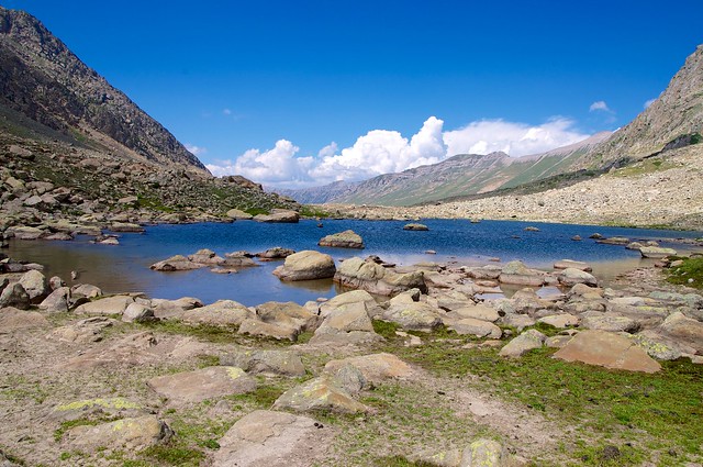
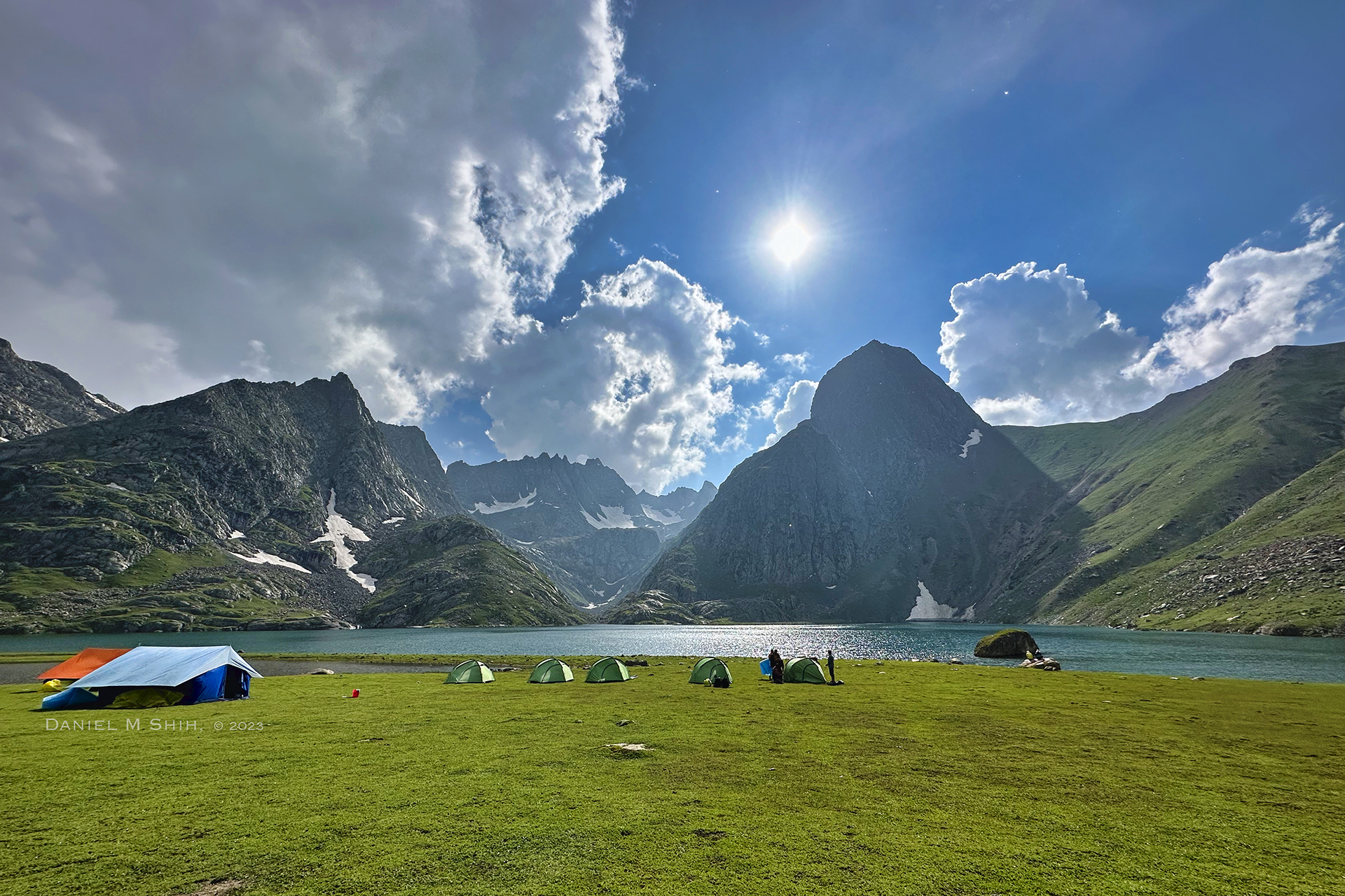
Gadsar Lake appears suddenly, sitting wide and calm around 12,000 ft. One side stays green. The other holds snow well into summer. It looks like a perfect campsite. Sometimes, it is not.
Cold winds funnel through the basin at night, and ground moisture rises quickly. If the weather turns, comfort drops fast. This is why many groups move ahead unless conditions are ideal. If you do camp here, leave the area clean. Damage shows fast in this basin, and recovery is slow.
Army Checkpoint: Expect 1–3 Hour Delays
The trail beyond Gadsar feels relaxed at first. Shepherd huts appear. The valley opens. Then the army camp stops you.
IDs are checked and permissions are cleared with headquarters. Signal issues often delay responses. We have waited one hour here. We have waited three. These delays affect the entire next day if you do not plan buffer time.
Carry original government ID such as Aadhaar or passport. Photocopies are not accepted. Keep it accessible.
What Surprised Us on Day 5
- How early fatigue sets in compared to earlier days
- How strong the wind feels at the pass even under clear skies
- How knee pain matters more than breathing on the descent
- How army delays shape the itinerary more than terrain
Common Mistakes Trekkers Make
- Starting late and crossing the pass after noon
- Rushing the initial climb and burning energy early
- Carrying too little water before the pass
- Underestimating wind chill at high points
This day is not about scenery alone. It is about judgment. Pace control. Weather timing. Energy management. Do this day right, and the trek opens beautifully afterward. Do it wrong, and it drains you.
This day does not reward shortcuts. It rewards calm decisions and steady steps.
Day 6: Gadsar to Satsar
- Trek Distance: 11–12 km (4.5–5 hours)
- Altitude Loss: 12,000 ft (3,658 m) – 11,800 ft (3,600 m)
- Highest Point: Maengandob area – 12,000 ft (3,658 m)
- Difficulty: Moderate
- Trail Type: Rocky terrain, alpine meadows, gentle undulations
- Water Sources: Multiple streams; carry 2L from start
- Mobile Network: None
- Special Note: Army checkpoint before Satsar lakes
The walk from Gadsar to Satsar is a moderate, endurance-based trekking day where pacing, camp choice, and terrain reading matter more than speed.
We leave Gadsar knowing there is no dramatic high pass today. Instead, this day quietly decides how fresh you feel for the remaining trek. Most trekkers underestimate it for that exact reason.
Early climb from Gadsar: where pacing decides the rest of the day
The day begins with a cold stream crossing near the Gadsar campsite, followed immediately by a steady climb. This ascent gains roughly 500 ft over 1.5 hours.
Here is the first real decision point.
If you climb fast here → breathing spikes early → legs feel heavy by mid-day → the flat section feels endless.
The terrain is rocky, uneven, and dotted with shallow craters. Foot placement matters. Loose stones can roll under tired ankles, especially if the group bunches up.
We always slow the group intentionally here. Short steps. Controlled rhythm. This is not a place to prove fitness.
Transition zone near Maengandob: flat ground, hidden risks
Around 11,800 ft, the trail exits the river valley and flattens into a wide alpine meadow known locally as Maengandob.
This is a classic morale trap.
The walking becomes easy, but weather exposure increases. There is no tree cover. Wind funnels through this basin by late morning, and cloud build-up often starts earlier than expected.
If clouds roll in here → visibility drops → navigation slows → time estimates stretch.
To the right, deep natural craters puncture the meadow floor. They look harmless, but poor visibility makes them ankle hazards. Staying on the defined trail is important even when it feels unnecessary.
Tactical decision: where you camp at Satsar actually matters
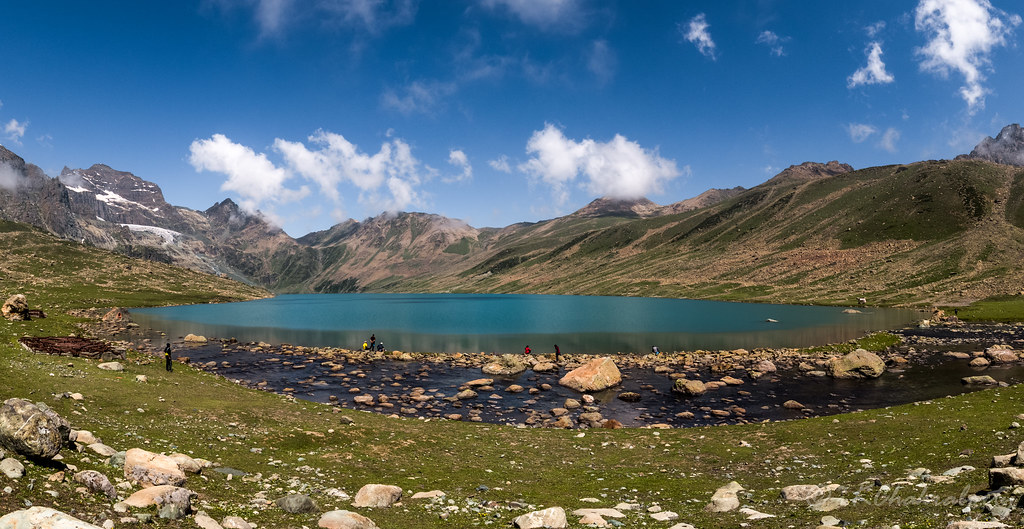
Satsar is not one lake. It is a series of seven interconnected alpine lakes, and water levels shift every season.
You will encounter an army check post before reaching the lakes. IDs are verified here. There is no bypass. Completing this today is important, because tomorrow’s walk flows better once this formality is done.
About 10 minutes beyond the post, the first Satsar lake appears.
If energy levels are strong → continue slightly ahead → camp closer to the inner lakes → expect quieter surroundings and better morning light.
If fatigue has set in → camp near the first lake → recover early → expect a stronger next day.
What you should not do is push forward just for a “better view.” All Satsar campsites are scenic. Recovery is the priority.
Descent into Satsar: gentle terrain, tired legs
The descent toward Satsar is gradual but long enough to strain knees that are already fatigued. The trail passes through grassy shelves and crosses several shallow streams.
Cold air settles early here in the evening. Stretching soon after reaching camp helps more than waiting until night.
The silence around Satsar is striking. Wind moves softly. Water reflects cleanly. There is very little ambient noise, even during peak season.
Common mistakes trekkers make
- Starting late and walking into afternoon cloud cover
- Drinking less water because the weather feels cold
- Rushing the initial climb and paying for it later
Fix these three, and this day feels controlled instead of draining.
Why Day 6 quietly shapes the rest of the trek
Day 6 does not impress with drama. It rewards discipline and judgement.
Walk steady. Eat on time. Choose camp wisely.
Do that, and Satsar feels less like another stop and more like a reset before the final stretch of the Kashmir Great Lakes Trek.
Key takeaways
- Pace early to protect energy later
- Flat sections can be deceptive at altitude
- Camp choice affects recovery, not scenery
- Weather awareness beats raw fitness
If earlier days tested your legs, this day tests your decision-making. On this trek, that is what keeps things enjoyable and safe.
Day 7: Satsar to Gangabal Twin Lakes via Zaj Pass
- Trek Distance: 9–10 km (6–7 hours)
- Altitude Loss: 11,800 ft (3,600 m) – 11,700 ft (3,570 m)
- Highest Point: Zaj Pass – 13,300 ft (4,054 m)
- Difficulty: Moderate to Difficult
- Trail Type: Boulder sections, rocky ascent, steep descent
- Water Sources: Seasonal streams before and after pass
- Mobile Network: Weak/intermittent near Gangabal
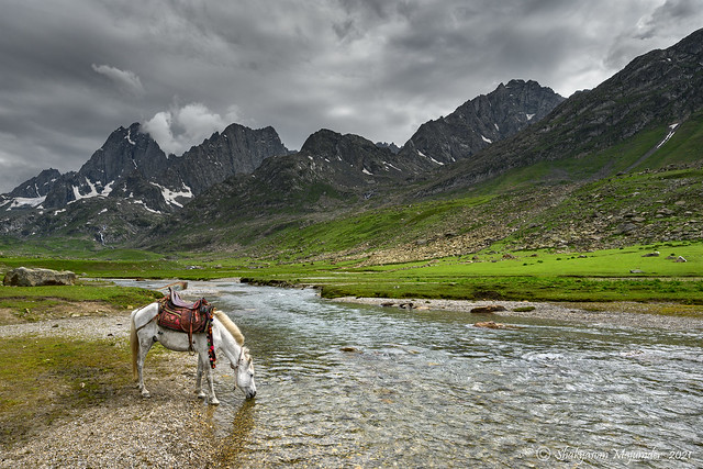
- Special Note: Mount Harmukh (16,870 ft / 5,142 m) visible
It is the most decisive day of the Kashmir Great Lakes Trek because it tests timing, patience, and judgment. This is not just about covering distance today. We always treat this as a transition day, where terrain, weather, and fatigue meet at once. If you manage this day well, the rest of the trek feels earned.
Leaving Satsar early matters
We leave Satsar early, usually soon after sunrise, because this day rewards discipline. Morning light spreads softly across the lakes, and the air still feels calm and stable. That calm does not last long once you gain height. If you delay the start, you carry heat, clouds, and pressure into the climb.
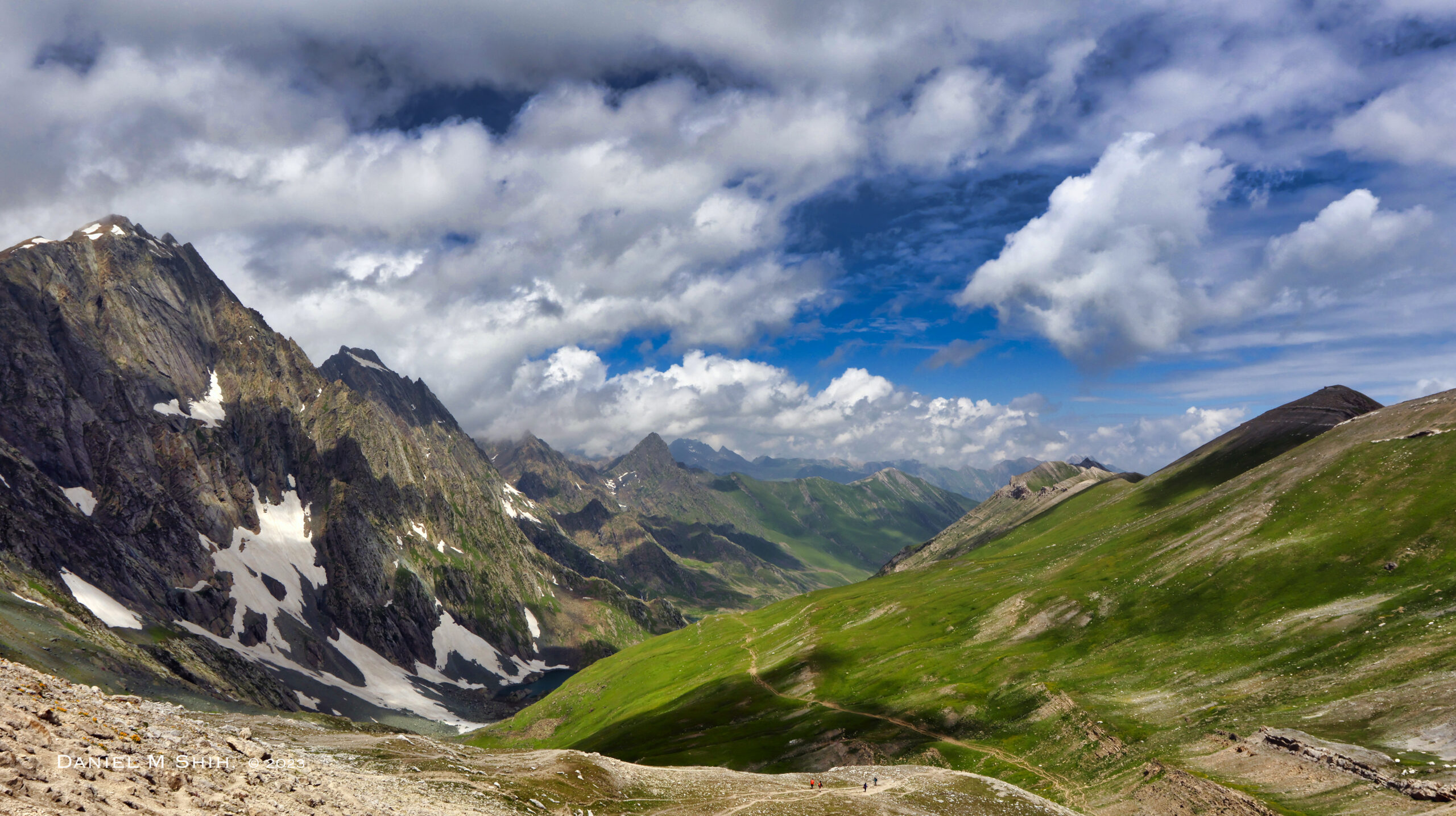
The trail begins with a gradual rise over uneven rock and scattered boulders. Every step feels harmless at first, but the ground slowly demands focus. Satsar fades behind you, and the route ahead becomes clear. Zaj Pass does not hide itself, and that honesty helps you pace better.
Climbing toward Zaj Pass
The climb to Zaj Pass tests patience more than strength. Loose stones force careful foot placement, and rushing only drains energy. We often remind trekkers here that speed does not save time today. A slow, steady rhythm keeps breathing controlled and legs responsive.
This section also demands real decisions, not just effort.
If clouds begin forming before noon → keep moving with short breaks → expect colder wind near the top
If the climb feels harder than expected → shorten your stride and slow down → expect better recovery after the pass
The weather usually shifts after early afternoon in this zone. Crossing before midday reduces exposure and mental stress. That single choice often decides how the day feels.
At the top of Zaj Pass
Zaj Pass opens suddenly, without drama or warning. Valleys drop away on both sides, and the scale of the landscape returns all at once. Many trekkers stop too long here because the view feels earned. We keep breaks short because the wind builds fast at this height.
Judgment matters more than celebration at the top.
If visibility drops suddenly → stay close to the worn trail line → expect firmer footing once the descent begins
Standing still too long cools the body quickly. Calm movement keeps control.
The descent into Gangabal valley
The descent after Zaj Pass feels steeper than most expect. Loose rock shifts underfoot, and knees take more load than lungs. Trekking poles help more here than anywhere else today. Careless steps are punished fast on this stretch.
One navigation detail helps avoid trouble.
After the third visible stream crossing → stay left toward the stone cairns → expect a safer and smoother descent
Cutting straight down looks tempting but often leads to slips and delays. As you descend further, pine trees appear and the air cools. You may notice simple Gujjar huts near the forest edge, marking the shift from open alpine land to shelter.
Reaching Nundkol and Gangabal Lakes
Nundkol Lake appears first and feels calm after the demanding descent. Many trekkers rest here, and it is a wise pause. From Nundkol, the trail smooths out but still needs attention. Gangabal reveals itself gradually, not all at once.
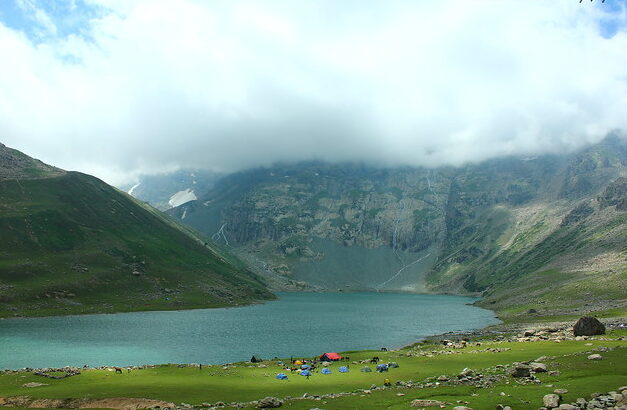
Gangabal Lake sits wide and deep beneath Harmukh. The twin lakes lie close together, separated by a narrow ridge. Even with other camps nearby, the area feels quiet. Most people feel the scale of the trek fully only after reaching this basin.
Campsite realities and night conditions
Camping near Gangabal is open and cold once the sun sets. Wind often rises after dark, especially in clear weather. We choose slightly raised ground away from the water for better shelter. Night temperatures drop sharply even during peak season.
Phone networks are unreliable here. A weak signal may appear briefly on lower sections, but it cannot be trusted. This is why group coordination and planning matter before leaving camp.
Safety thinking for the day
This day rewards prepared thinking more than physical strength.
If someone feels injured after the descent → stop at Gangabal camp → expect help only from your trekking team
If weather worsens after crossing the pass → continue steadily toward forest cover → expect safer conditions below the tree line
There is no quick exit route today. Calm decisions matter more than speed.
Why this day stays with people
Day 7 stays memorable because it demands judgment, not heroics. You leave behind the high lake plateau and enter the Harmukh basin. The effort feels heavy but purposeful. This is where the trek stops feeling scenic and starts feeling earned.
Key Takeaways
- Start early to manage weather risk
- Pace slowly on the climb to save energy
- Descend carefully and follow established trails
- Expect cold nights near Gangabal
- Trust timing and patience more than speed
This day rewards those who think ahead.
Day 8: Gangabal to Naranag, Drive to Srinagar
- Trek Distance: 13–15 km (6–7 hours)
- Altitude Loss: 11,700 ft (3,570 m) – 7,450 ft (2,271 m)
- Difficulty: Moderate (knee-intensive)
- Trail Type: Ridge walk, steep forest descent, stone path
- Water Sources: Limited; fill bottles at Gangabal
- Mobile Network: Postpaid may work near Naranag
- Drive to Srinagar: 2 hours (70–77 km)
- Army Checkpost Deadline: 4:00 PM (non-negotiable)
This day is the longest descent of the Kashmir Great Lakes Trek and the most demanding day for tired knees. You start from Gangabal Lake at 11,700 feet and finish at Naranag village, losing close to 4,250 feet in one day. The distance itself is manageable, but the continuous downhill makes this day unforgiving if paced poorly. This is where judgment matters more than stamina.
The trail begins from the Gangabal campsite and initially descends gently along a ridge. It is important to stay on this ridge and not walk beside the stream. The ground near the water looks tempting but turns soft and uneven quickly. Staying higher keeps the trail firm and your footing predictable.
For the first few kilometers, the descent feels easy and controlled. You gradually drop to around 10,800 feet, then climb back up close to 11,000 feet before the real descent begins. This brief regain in altitude surprises many trekkers and often leads to early overconfidence. Harmukh Peak remains visible behind you, and the walking feels relaxed at this stage.
After covering roughly two-thirds of the distance, the character of the trek changes sharply. The trail enters dense pine forest and begins a steep, uninterrupted drop. Over the final four kilometers, you lose more than 3,000 feet in altitude. The path here is muddy, well-trodden, and relentless, and this is where knees and ankles take the maximum load.
If the trail turns slippery, shorten your stride and keep your steps controlled. If rocks feel loose, plant your heel firmly before shifting weight forward. Rushing this stretch increases the risk of knee strain and ankle slips. Short, regular pauses help far more than pushing through discomfort this late in the trek.
As you descend further, you start crossing locals trekking up from Naranag toward Gangabal. The village appears far below earlier than expected, but the remaining descent is longer than it looks. Maintain the same controlled pace until you reach the village track.
The final approach shifts onto a stone-paved path, signaling the end of technical terrain. Naranag sits at around 7,450 feet and marks the official end of the trek. Stretch your legs here before resting, as stiffness sets in quickly during the drive if you skip this step.
Water sources are limited after leaving Gangabal. Fill your bottles fully in the morning. While small streams appear early in the descent, reliable refill points reduce sharply once you enter the forested section.
Exit timing is non-negotiable.
The security checkpost near Naranag closes at 4:00 pm. If you arrive after this time, delays are almost certain and arrangements become stressful. Start early from Gangabal and plan to reach Naranag by mid-afternoon to ensure a smooth exit.
The drive from Naranag to Srinagar takes around two hours, and most trekkers reach the city by evening if timings are managed well. Mobile connectivity remains unreliable through the day. Prepaid SIM cards rarely work consistently, while postpaid connections may catch brief signals closer to the road.
If time permits, the Naranag Temple complex near the road is worth a short stop. The ancient stone ruins sit quietly against forested slopes and offer a grounded cultural close after days spent in high alpine terrain.
Key Takeaways
- Expect a total altitude loss of nearly 4,250 feet
- Stay on the ridge early and avoid walking beside the stream
- Be prepared for a short altitude regain before the final steep descent
- Protect your knees during the last four kilometers
- Reach Naranag before 4:00 pm to avoid checkpost delays
Day 8 does not test fitness. It tests discipline.
What’s the difficulty level of Kashmir Great Lakes Trek?
Kashmir Great Lakes Trek sits in the moderate to challenging range. It covers about 70 to 72 kilometers across 7 to 8 trekking days. The highest point reaches close to 13,750 feet at Gadsar Pass. Most trekkers who keep a steady pace finish without major trouble. But make no mistake. This trek rarely feels easy once altitude starts building.
We often tell trekkers that this route rewards patience more than raw fitness. Why? Because the difficulty creeps up slowly rather than hitting you all at once.
The trail starts near Sonamarg at around 7,800 feet. Breathing feels normal here. Walking feels comfortable. After two or three days, something shifts. The same pace starts feeling heavier. First-time high altitude trekkers often notice this change first. Their legs work fine, but their lungs ask for more breaks.
The climb toward Gadsar Pass is where reality hits most people. This stretch falls on Day 5, from Vishansar to Gadsar. Many trekkers call it the hardest day of the entire route. The trail stays exposed for long sections. The ground feels loose underfoot. You end up taking slower, more careful steps whether you want to or not.
Why does this trek feel demanding even on flat sections? Trail surfaces keep changing. One hour you walk through wide grass valleys. Feels smooth. Almost relaxing. Then the path turns rocky. You cross glacier streams. Early season batches deal with snow patches too. Your body keeps adjusting to these small shifts. That adjustment quietly builds fatigue over days.
Kashmir weather adds another layer. Sunny mornings can turn cold and windy by lunch. We have seen trekkers start a day in t-shirts and end it in down jackets.
Here are the key factors that shape this trek’s difficulty:
- Three high passes to cross: Nichnai Pass at 13,200 feet, Gadsar Pass at 13,750 feet, and Zaj Pass at 13,300 feet
- Daily distance ranges from 9 to 15 kilometers
- Walking hours stretch between six and eight each day
- The trek involves roughly 4,500 to 5,000 feet of total elevation gain
- Weather shifts fast and affects comfort throughout
Who struggles most on this trek? Usually first-timers attempting their first multi-day high altitude journey. Trekkers who already enjoy long walks or weekend hill hikes settle into the rhythm faster. We have watched many people doubt themselves before their first pass. That doubt fades once they reach the top and realize their body can handle it.
Want to know which days feel toughest? Our detailed Kashmir Great Lakes Trek difficulty guide breaks down the challenge day by day.
What’s the Best Time for Kashmir Great Lakes Trek
July to early September is the best time for the Kashmir Great Lakes trek, with August hitting the sweet spot for most trekkers. Outside this window, heavy snow buries the passes and makes the trail inaccessible. We run our batches only during these months because the weather cooperates, the lakes thaw completely, and the meadows explode with wildflowers.
But why does Kashmir open for trekking during monsoon when Uttarakhand and Himachal shut down? The Pir Panjal range blocks most rain clouds before they reach the Kashmir Valley. So while trails near Rishikesh turn into muddy streams, the KGL trail enjoys clear skies with just occasional evening drizzles.
Read The Complete Guide on: Best Time for Kashmir Great Lakes Trek
Kashmir Great Lakes Trek in June
June opens the season but comes with challenges. Expect significant portions of the trail under snow, especially at Nichnai Pass and Gadsar Pass (13,750 ft). The lakes stay partially frozen with ice sheets floating on turquoise water. Daytime temperatures range from 15°C to 20°C while nights drop to freezing or below. Pick June only if you have prior snow trekking experience and want solitude on untouched trails.
Get the More Details on This Month: Kashmir Great Lakes Trek In June
Kashmir Great Lakes Trek in July
July brings the real transformation. Snow retreats from most sections by mid-month. The famous wildflower bloom begins, carpeting meadows around Vishansar and Gadsar in purple, yellow, and blue. Temperatures climb to 15°C to 20°C during the day, settling at 2°C to 7°C at night. Early July still shows snow patches on high passes while late July offers nearly clear trails with peak flower colors.
This May Help You to Plan your Trek: Kashmir Great Lakes Trek in July
Kashmir Great Lakes Trek in August
August delivers the classic KGL experience. All seven alpine lakes become crystal clear, reflecting snow-capped peaks like polished mirrors. The Gadsar meadows reach their greenest, and weather stays predictable with temperatures between 15°C and 22°C. The tradeoff? August draws the biggest crowds. Start trekking by 6:30 AM to cross passes before afternoon clouds and secure good campsites.
Kashmir Great Lakes Trek in September
September shifts the mood entirely. Skies turn remarkably clear, meadows fade from green to golden amber, and trekker numbers drop sharply. Temperatures cool to 14°C to 18°C during the day and 0°C to 5°C at night. By mid-September, snow can return to the high passes without warning. Choose early September if you want autumn colors and solitude but carry extra warm layers.
How to Reach the Base Camp of Kashmir Great Lakes Trek
Reaching the base camp of Kashmir Great Lakes Trek requires meticulous planning to ensure a seamless journey. Below, we provide a comprehensive guide to help you reach the starting point of the trek with ease.
Step 1: Reaching Srinagar
By Air: Flying is the easiest and fastest way to get to Srinagar. The Sheikh ul-Alam International Airport connects well with cities like Delhi, Mumbai, Bangalore, and Chennai. Many direct flights are available daily. You can save a lot of travel time by choosing this option.
Tip: Book your flight to Srinagar for Day 0, a day before the trek. This gives you enough time to rest and adjust to the new place.
By Train: Srinagar does not have a direct train connection. The nearest big railway station is Jammu Tawi Railway Station. From Jammu, you can:
- Take a shared cab or a bus to Srinagar.
- Travel by train to Banihal and then take another train or shared cab to Srinagar.
Pro Tip: The train ride from Banihal to Srinagar is stunning. It passes through green valleys and tunnels, offering beautiful views of the region.
By Road: If you love road trips, buses and shared cabs run from Jammu to Srinagar. The journey takes about 8-12 hours, depending on the road and weather conditions.
Note: Be ready for a long and winding drive through the mountains.
Step 2: Staying in Srinagar
It’s best to arrive in Srinagar one day before the trek starts. This will allow you to rest and explore the city. Here are some good places to stay:
- Hotel Chinar Inn
- Location: Close to the trek pickup point.
- Cost: INR 1,500 per person for a twin-sharing room. The price includes dinner and breakfast.
- Single room: INR 2,300 per person, including meals.
- Royal Athena Houseboats
- Stay on a luxurious houseboat with all modern amenities.
- Cost: INR 1,750 per person, including dinner and breakfast.
- Alhamra Retreats
- A cozy guesthouse offering flexible room-sharing options.
- Cost:
- Twin-sharing: INR 2,100 per room.
- Triple-sharing: INR 2,800 per room.
- Four-sharing: INR 3,500 per room.
- Extra bed: INR 700 per person.
Step 3: Traveling from Srinagar to Sonamarg
The trek begins at Sonamarg, which is around 80 kilometers from Srinagar. The journey takes about 3-4 hours. There are two ways to reach base camp of Kashmir Great Lakes Trek:
By Private Taxi: Hiring a private taxi is the most comfortable way to travel to Sonamarg. The ride is smooth, and you can enjoy the views at your own pace.
By Shared Cab: Shared cabs are a budget-friendly option. You can find them at the Tourist Reception Center (TRC) in Srinagar. The fare is around INR 300-500 per person.
Travel Tip: Start early in the morning to see the beautiful views of the Sind River and snow-capped mountains along the way.
Important Travel Tips
- Buffer Day: Always keep one extra day in your travel plan. Bad weather or roadblocks can delay your journey.
- Travel Light: Pack only the essentials. Your trekking bag should include warm clothes, trekking shoes, and personal items.
- Stay Connected: Phone networks in Sonamarg can be weak. Prepaid SIM cards from Jio or Airtel work best.
- Health Precautions: Rest in Srinagar for at least one day to adjust to the altitude. Drink plenty of water to stay hydrated.
Step 4: Returning from the Trek
The trek ends at Sonamarg, and transportation is arranged to take you back to Srinagar. Plan your return from Srinagar based on your preferred mode of travel.
By Air: Flying is the quickest way to return home. Book your flight for the day after the trek ends. Don’t forget to include the buffer day in your plan.
By Train: Travel from Srinagar to Banihal by train or shared cab. From Banihal, you can take another train to Jammu Tawi Railway Station for your onward journey.
By Road: Shared cabs and buses are available from Srinagar to Jammu. This is a good option if you prefer road travel.
Things to Carry for Your Great Lakes Trek
Below we have provided you a complete guide on packing essentials for Kashmir Great Lakes Trek.
1. Essential Documents
- Government-issued ID: Carry an original ID such as an Aadhaar card, passport, or driving license.
- Trekking Permits: Ensure you have the required permits for the trek, issued by the local authorities.
- Medical Certificates: Obtain a fitness certificate and any other medical documents necessary for the trek.
- Insurance Documents: A travel insurance policy that covers high-altitude trekking is highly recommended.
2. Clothing
Layering for Different Weather Conditions
The weather in Kashmir can be unpredictable, so layering is key.
- Base Layer: Moisture-wicking thermal tops and leggings.
- Insulation Layer: Fleece or down jackets to keep you warm during cold nights.
- Outer Layer: Waterproof and windproof jackets and trousers.
- Trekking Shirts: Lightweight, quick-dry shirts.
- Trekking Pants: Convertible or water-resistant trekking pants.
- Warm Cap: To protect against cold winds, especially in the mornings and evenings.
- Gloves: Insulated and waterproof gloves.
- Socks: Woolen socks for colder temperatures and synthetic socks for trekking.
- Rain Gear: Ponchos or rain jackets, and rain covers for your backpack.
3. Footwear
- Trekking Boots: High-quality, ankle-support trekking boots with a good grip.
- Camp Shoes: Lightweight, comfortable shoes for evenings at the campsite.
- Gaiters: Useful for trekking through snow or muddy trails.
4. Backpack and Accessories
- Backpack: A 50–60-liter backpack with sturdy straps and good back support.
- Daypack: A small, foldable bag for day hikes or carrying essentials during the trek.
- Rain Cover: Protect your backpack from rain and snow.
5. Personal Care Items
Hygiene
- Biodegradable Toiletries: Soap, toothpaste, and shampoo.
- Toilet Paper: Essential for personal hygiene.
- Wet Wipes: For quick cleaning when water is not readily available.
- Sunscreen: High SPF to protect against harsh UV rays.
- Lip Balm: Prevent chapped lips in cold conditions.
- Sanitizer: Alcohol-based sanitizer for cleanliness.
- Towel: Lightweight, quick-dry microfiber towel.
Medical Kit
- Painkillers: For minor aches and pains.
- Band-aids and Blister Pads: For foot care during long treks.
- Antiseptic Cream: For treating cuts or scrapes.
- Anti-inflammatory Medicine: In case of muscle or joint inflammation.
- Altitude Sickness Medication: Such as Diamox.
- Rehydration Salts: To prevent dehydration.
6. Food and Hydration
- Snacks: Energy bars, dry fruits, nuts, and chocolates for quick energy boosts.
- Electrolytes: Hydration powders or tablets.
- Water Bottles: At least two 1-liter bottles or a hydration bladder.
- Portable Water Filter: LifeStraw or similar products to purify water from natural sources.
7. Trekking Gear
- Trekking Poles: Essential for stability and reducing strain on your knees.
- Headlamp or Torch: With extra batteries for nighttime visibility.
- Sunglasses: UV-protected sunglasses to prevent snow blindness.
- Cap or Hat: Wide-brimmed hat for sun protection.
- Buff or Scarf: To shield your face from dust and cold winds.
- Multi-tool Knife: For emergencies or small repairs.
8. Electronics
- Power Bank: To charge your devices during the trek.
- Camera: To capture the stunning landscapes.
- Spare Batteries: Cold weather can drain batteries quickly.
- Phone: Preloaded with maps and emergency contacts.
Fitness Tips & Importance of Kashmir Great Lakes Trek
Lack of fitness preparations for Kashmir Great Lakes Trek can lead to problems. You might feel tired, get altitude sickness, or hurt yourself. These issues can ruin your experience or even make you quit the trek.
Being physically ready helps you handle long hours of walking. Mental strength keeps you going when it gets hard. Whether you are an experienced trekker or a beginner, it is important to prepare your body and mind for this trek.
Pre-Trek Fitness Preparation
1. Build Aerobic Endurance
The Kashmir Great Lakes Trek involves walking for up to 8 hours daily. You will often walk on steep paths. You need strong lungs and good stamina to keep up without feeling out of breath. Add these exercises to your routine:
- Running or Jogging: Run for 30–40 minutes, 4–5 days a week. Start with short distances and slowly increase how far you run.
- Cycling: This builds leg strength and improves stamina. Go for long rides 1–2 times a week.
- Swimming: Swimming is gentle on your body but great for your lungs and endurance.
2. Focus on Strength Training
Strong legs and a strong core are very important for trekking. You need them to climb hills and stay safe from injuries. Try these exercises:
- Squats: Do 3 sets of 15 squats every day. These strengthen your thighs, hips, and knees.
- Lunges: Forward and reverse lunges help your legs stay strong for climbing and descending.
- Step-Ups: Use a sturdy bench or platform. Step up and down for 3 sets of 10 per leg. This helps mimic trekking movements.
- Deadlifts and Plank Holds: These exercises make your back and stomach muscles stronger. They help you carry your backpack with ease.
3. Train for Altitude Acclimatization
High-altitude trekking is tough because there is less oxygen in the air. This can cause altitude sickness, which makes you feel tired or dizzy. Prepare for this by:
- Practicing breath-holding exercises to improve your lung strength.
- Using masks that simulate high-altitude conditions during workouts.
- Hiking in nearby hilly areas. This gets your body used to the thinner air gradually.
4. Build Flexibility
Flexible muscles and joints keep you safe from injuries. Stretching exercises and yoga can help loosen your muscles. Focus on these areas:
- Hamstrings and Calves: These muscles work a lot during the trek.
- Hips and Shoulders: Stretching these areas helps with movement and carrying a backpack.
Add these yoga poses for flexibility:
- Downward Dog: This stretches your back and legs.
- Warrior Pose: Builds strength and balance.
- Cobra Pose: Opens up your chest and makes your back stronger.
Read the Complete Information on: Kashmir Great Lakes Trek Do’s and Don’ts
Beautiful Great Lakes on Your Trek
Satsar Lakes
Satsar Lakes are a group of seven small lakes. These lakes are at 12,000 feet. Each lake has its own charm. The lakes are fed by melting glaciers, so the water is very clear. The trek to Satsar is exciting. You pass through rocks, green fields, and lovely views. The area is perfect for camping or exploring. You can enjoy nature and have fun discovering the lakes. It is a special place for trekkers.
Gangabal Lake
Gangabal Lake is called the “Lake of Shiva.” It is the last major lake on the trek. At 11,500 feet, it is at the base of Mount Harmukh. The water is very clear and reflects the tall mountain. Many people come here because it is a sacred spot. Pilgrims and trekkers visit every year. The lake is also famous for trout fishing. The peaceful beauty of Gangabal Lake is perfect for ending your trek.
Nundkol Lake
Nundkol Lake is next to Gangabal Lake. It is smaller but just as beautiful. The lake is fed by snow from Mount Harmukh. It is a quiet spot, away from crowds. The clear water reflects the nearby peaks. Green fields around the lake make it perfect for camping. You can sit here and enjoy the calm. The lake feels peaceful and relaxing. Nundkol Lake is a hidden gem for those who love nature.
Top Photography Spots on Kashmir Great Lakes Trek
Sonamarg
Sonamarg is where the trek begins. It has green meadows, tall mountains, and a lovely river called the Sindh River. The view is perfect for wide, beautiful photos. Sheep and small villages add to the charm.
📸 Tip: Use a wide lens to show the big valley and include the river for depth.
Nichnai Pass
On your way to Nichnai Pass, you’ll see fields of colorful flowers. At 13,000 feet, the pass offers amazing views of mountains and valleys.
📸 Tip: Take photos early in the morning when the valley has soft mist for a dreamy look.
Vishansar Lake
Vishansar Lake is famous for its crystal-clear water. The lake reflects the sky and mountains like a perfect mirror. Its color changes from blue to turquoise during the day.
📸 Tip: Use a polarizing filter to make the colors brighter and cut down glare.
Krishansar Lake
Close to Vishansar, Krishansar Lake is quieter but just as beautiful. The green water and surrounding meadows make it a magical spot. You might also see birds here.
📸 Tip: Try long-exposure shots to show the calm ripples on the water.
Gadsar Pass
At 13,700 feet, Gadsar Pass gives stunning views of two lakes on one side and the valley on the other. It’s a great place for wide, panoramic shots.
📸 Tip: Add people or trekkers in your photo to show how big the mountains are.
Gadsar Lake
Gadsar Lake is surrounded by colorful wildflowers. The clear water reflects the sky and mountains, creating perfect photos.
📸 Tip: Use flowers in the foreground for a beautiful frame.
Satsar Lakes
The Satsar Lakes are seven small lakes connected by streams. They are surrounded by rocky meadows and are perfect for landscape and wildlife photos.
📸 Tip: Take photos during sunrise or sunset for golden light.
Zaj Pass
Zaj Pass offers some of the most dramatic views of the trek. You can see valleys, meadows, and glaciers from here.
📸 Tip: Use a zoom lens to capture details of the faraway peaks.
